
Some links on this page are affiliate links. If you book or buy through them, I earn a small commission — at no extra cost to you. How this site is funded →
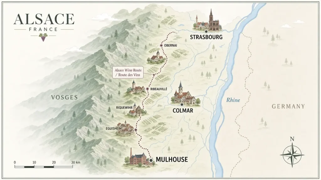
Alsace is a long, narrow strip of north-eastern France squeezed between the Vosges mountains and the Rhine. Once you understand that shape, planning becomes simple: almost everything you want to see sits within a 30-kilometre-wide band, and nothing is more than about 90 minutes from anything elsebut the far north and far south are considerably farther apart: Wissembourg to Mulhouse takes roughly two hours by car. This page explains the geography, the Bas-Rhin / Haut-Rhin split, and the real distances you should plan around.
In short
- Alsace runs roughly 190 km north to south and is rarely more than 50 km wide. The Vosges are always to the west, the Rhine and Germany always to the east.
- Two departments: Bas-Rhin in the north (capital Strasbourg) and Haut-Rhin in the south (capital Colmar). Confusingly for English speakers, « Bas » (lower) means north and « Haut » (upper) means south, because the Rhine flows northwards.
- Strasbourg to Colmar is about 70 km — around an hour by car, 30 to 40 minutes by direct train.
- The wine villages sit on the hillside foothills, west of the flat plain and the A35 motorway. The plain itself is farmland; the scenery starts when you turn towards the hills.
- One base is enough for a first trip. Two bases only make sense if you are combining the far north (Wissembourg) or the far south (Mulhouse, Sundgau) with the wine country.
Where is Alsace on the map of France?
Alsace occupies France’s north-eastern corner, along the German border. The Rhine forms that border for the region’s entire length, with Baden-Württemberg and the Black Forest on the far bank. Switzerland begins just south of Mulhouse, around Basel. To the west, the crest of the Vosges separates Alsace from Lorraine.
Administratively, Alsace is part of the Grand Est region, and its two departments are grouped in the Collectivité européenne d’Alsace. For a traveller, the practical takeaway is different: Alsace behaves like a border corridor. Basel, Freiburg and the Black Forest are genuinely close, which is why so many trips here combine countries. If that appeals, plan it deliberately rather than improvising — see how to combine Alsace, the Black Forest and Switzerland.
Bas-Rhin or Haut-Rhin: which half do you actually need?
Both departments have wine villages, castles, Christmas markets and half-timbered towns. The difference is density and character rather than quality.
| Bas-Rhin (north, 67) | Haut-Rhin (south, 68) | |
|---|---|---|
| Main city | Strasbourg | Colmar |
| Second hub | Sélestat, Obernai | Mulhouse |
| Wine Route section | Marlenheim to Dambach-la-Ville | Bergheim to Thann |
| Feel | Bigger towns, more spread out, fewer coach groups | Villages closer together, more concentrated tourism |
| Best for | City culture, cathedral, northern castles, quieter villages | Village-hopping without a car, classic postcard Alsace |
| Rail access | Excellent (TGV hub) | Good on the main line, thin off it |
If your trip is short and village-focused, the Haut-Rhin around Colmar packs more into less driving. If you want a city holiday with day trips, Strasbourg in the Bas-Rhin gives you more urban depth and better trains. The trade-offs are set out in detail in our guide to choosing where to base yourself in Alsace.
The three bands: plain, foothills, mountains
Read any map of Alsace west to east and you cross three distinct strips. Knowing which one you are in explains almost everything about the landscape and the driving.
- The Rhine plain (east). Flat, fertile, industrial in places, with the Rhine, its canals and the Ried wetlands along the river Ill. This is where the motorway, the main railway and the airports sit. Highlights are specific rather than scenic: the star-shaped Vauban fortress at Neuf-Brisach, the river crossings into Germany, the Écomusée.
- The foothills, or piedmont (middle). A narrow ribbon of vine-covered hills, 200 to 400 metres up, where nearly every famous village stands. This band is only a few kilometres wide, which is why villages are so close together.
- The Vosges (west). Forested mountains rising to the Grand Ballon at 1,424 m, with high passes, lakes and the ridge road known as the Route des Crêtes. Ruined castles perch on the first summits, the most visited being Haut-Kœnigsbourg above Orschwiller.
The practical consequence: if the hills are on your left as you drive, you are heading north; on your right, you are heading south. And if the landscape looks flat and ordinary, you are still on the plain — turn west for five to ten minutes and the vineyards begin.
Walkers should note that the transition is abrupt. You can be among vines and in deep forest within the same hour, which makes half-day walks unusually varied; the options are covered in our guide to hiking and the outdoors in Alsace.
Key distances and journey times
All figures below are approximate and assume normal conditions. Rural roads through the vineyards are slow by design — narrow, winding and worth it.
| Route | Distance | By car | By train |
|---|---|---|---|
| Strasbourg → Colmar | ~70 km | ~1 h | ~30–40 min, direct |
| Strasbourg → Obernai | ~30 km | ~35 min | ~30 min |
| Strasbourg → Sélestat | ~50 km | ~45 min | ~20–25 min |
| Colmar → Eguisheim | ~7 km | ~15 min | no station |
| Colmar → Riquewihr | ~15 km | ~25 min | no station |
| Colmar → Kaysersberg | ~12 km | ~20 min | no station |
| Colmar → Haut-Kœnigsbourg | ~25 km | ~40 min | no station |
| Colmar → Mulhouse | ~45 km | ~40 min | ~25–30 min |
| Strasbourg → Mulhouse | ~115 km | ~1 h 15 | ~50 min–1 h 15 |
| Strasbourg → EuroAirport (Basel) | ~140 km | ~1 h 30 | change required |
| Paris → Strasbourg | ~490 km | ~4 h 30–5 h | ~1 h 50 by TGV |
Two things stand out. First, the north–south axis is fast: the A35 motorway runs the length of the plain and is toll-free. Second, the east–west moves are slow: crossing into the Vosges or over a pass eats time, especially in winter when sections of the ridge road are usually closed by snow. Check road status locally before planning a mountain crossing in the colder months.
Because the villages have no railway stations, a car transforms what you can see in a day. A small vehicle is genuinely easier here — village lanes are tight and car parks are compact. Demand peaks sharply in September for the harvest and throughout December, so booking early for those months is sensible rather than dramatic. Read the practical detail in our car hire guide for Alsace.
[AFF-SLOT | car-rental | compact car pick-up at Strasbourg or EuroAirport for a plain-and-vineyard loop]
How to read the Wine Route on a map
The signposted Route des Vins runs roughly 170 km from Marlenheim, just west of Strasbourg, to Thann in the south. It does not follow a single road: it threads between villages along the foothills, crossing and recrossing minor roads, which is why a paper map or an offline route on your phone matters more here than elsewhere. Our dedicated Wine Route map and route breakdown shows how the sections fit together.
Northern section
From Marlenheim down to around Dambach-la-Ville, taking in Molsheim, Obernai, Barr and Mittelbergheim. Wider spacing between villages, more working agriculture, noticeably fewer visitors. Best reached from Strasbourg. Details in the northern Wine Route guide.
Central section
The dense stretch between Bergheim and Turckheim: Ribeauvillé, Hunawihr, Riquewihr, Kaysersberg, Ammerschwihr. Villages are two to five kilometres apart, so you can walk or cycle between several in a day. This is the section most first-timers picture, and it is covered in the central Wine Route guide.
Southern section
From Eguisheim through Gueberschwihr, Rouffach and Guebwiller to Thann. Steeper slopes, big Grand Cru names, quieter lanes. See the southern Wine Route guide for how to string it together.
For the wider context — driving, cycling, cellar visits and timing — start from the complete Alsace Wine Route guide.
The parts of Alsace most visitors never open on the map
- Northern Alsace (Outre-Forêt and the Northern Vosges). Above Strasbourg, around Wissembourg, with sandstone castles and villages of white-and-black timber framing such as Hunspach and Seebach. Very different in appearance from the wine villages, and included in our round-up of the prettiest villages across Alsace.
- Alsace Bossue. The north-western corner, over the hills towards Lorraine. Rolling, rural, almost no tourism.
- The Sundgau. South of Mulhouse towards Switzerland, a land of ponds, carp-frying inns and hilly farmland.
- The Ried. Wet meadows and forests along the Ill between Sélestat and Strasbourg — flat, green and good for cycling.
- The Rhine itself. Cycle paths, locks, birdlife and easy bridges into Germany.
None of these are essential on a first trip. They matter if you are returning, travelling in high summer and want space, or building a slower Alsace road trip.
Orienting yourself without a car
The railway follows the plain, north to south, linking Strasbourg, Sélestat, Colmar and Mulhouse with frequent regional trains. Every wine village lies west of that line, off the rails, served by buses of varying frequency. That single fact shapes any car-free trip: you move by train along the axis, then switch to bus, bike, taxi or organised transport to reach the hills.
The most-searched leg of all is the hop between the two main cities, and it is genuinely easy — see Strasbourg to Colmar by train, bus or car. For network coverage, ticket types and how regional services work, our guide to travelling around Alsace by train has the detail, and getting around Alsace compares all the options side by side.
[AFF-SLOT | rail | Strasbourg–Colmar and Paris–Strasbourg rail connections]
Arriving by air changes your mental map too. Strasbourg’s airport sits just outside the city with a short rail link; the EuroAirport at Basel-Mulhouse-Freiburg serves the southern half and is the usual choice for Colmar-first trips. Compare them in our Alsace airports guide.
Using the map to choose your base
Draw a circle of about 40 km around Colmar and you capture the central and southern Wine Route, Haut-Kœnigsbourg, the Vosges foothills and the Rhine crossings. Draw the same circle around Strasbourg and you capture the cathedral city, the northern Wine Route and easy trains south. That is the whole decision in one image.
Villages themselves make lovely bases but hold very few rooms — a single village may have only a handful of hotels and guesthouses, and they fill first for September, December and long weekends. If a vineyard village is your preference, fix it early and build the rest of the trip around it.
[AFF-SLOT | accommodation | choosing between Strasbourg, Colmar and a vineyard village base]
Good to know before you plan around the map
- Kilometres lie in Alsace. Fifteen kilometres between villages can take 30 minutes on vineyard lanes, and longer in the harvest period when tractors have priority.
- Don’t judge Alsace from the motorway. The A35 runs through the flat plain. The scenery is one exit and ten minutes west.
- « Haut » means south, not high on the page. Haut-Rhin is at the bottom of the map. Check which department an address is in before booking.
- Village centres are often closed to traffic. Park in the signposted car parks on the edge and walk in; expect them to be busy from late morning.
- Mountain routes are seasonal. High Vosges passes and the ridge road can close in winter. Always have a plain-level alternative.
- Cross-border trips need a plan, not a whim. Germany is minutes away, but bridges are limited and public transport across them is patchy.
- Two bases rarely beat one. With distances this short, moving hotels usually costs more time than it saves. Our page on how many days you need in Alsace sets out realistic pacing.
Guided day trips solve the geography problem neatly for anyone without a car, particularly for the vineyard villages clustered west of Colmar. Small-group departures from the main cities cover three or four villages in a day, and seats in September and December go early.
[AFF-SLOT | tours | small-group Wine Route village day trip from Colmar or Strasbourg]
Frequently asked questions
How big is Alsace?
Alsace is one of France’s smaller historic regions: roughly 190 km from north to south and rarely more than 50 km wide, wedged between the Vosges crest and the Rhine. In practical terms, you can drive its full length in about two hours on the motorway, and no two major sights are more than 90 minutes apart.
Is Alsace in Germany or France?
Alsace is in France. It sits on the German border and changed hands several times between 1871 and 1945, which is why the architecture, dialect and food feel Germanic. Since 1945 it has been French without interruption. You will pay in euros and be understood in French, with English widely spoken in tourist areas.
What is the difference between Bas-Rhin and Haut-Rhin?
They are the two departments that make up Alsace. Bas-Rhin is the northern half, with Strasbourg as its capital; Haut-Rhin is the southern half, centred on Colmar and Mulhouse. The names refer to the Rhine’s flow, not to latitude: « lower Rhine » is downstream and therefore further north.
Where exactly is the Alsace Wine Route?
It follows the foothills between the flat Rhine plain and the Vosges mountains, from Marlenheim in the north to Thann in the south — roughly 170 km of signposted minor roads. Every well-known wine village lies on this narrow band, a few kilometres west of the main motorway and railway. The most beautiful Wine Route villages are concentrated in its central section.
How far is Colmar from Strasbourg?
About 70 km. Direct regional and high-speed trains take roughly 30 to 40 minutes, and driving takes around an hour on the A35. Both cities work as a base for the other, so there is no need to split your stay between them on a short trip.
Can I see Germany and Switzerland from Alsace?
Yes. The Black Forest hills are visible across the Rhine from much of the plain and from vineyard viewpoints, and on clear days the Alps can appear from the high Vosges. Basel, in Switzerland, is about 30 km south of Mulhouse, and the EuroAirport straddles the French-Swiss border.
Do I need a car to get around Alsace?
Not for the cities, yes for the villages. Trains link Strasbourg, Sélestat, Colmar and Mulhouse frequently, but the wine villages have no stations and rely on buses, bikes or tours. Car-free trips are entirely feasible with planning — see our car-free Alsace itineraries.